For highway, bridge and utility crews
Every jobsite photo, stamped with its station.
Station Cam puts the station, date, time and GPS on every photo your crew takes. Plot the stations from your plan set once, and the whole crew is set.
Coming soon to the App Store and Google Play.
-
No surveyor, no design filesYou need the station numbers on your plan set and a map. That's it.
-
Works with no signalStations are worked out on the phone, so the camera keeps going in dead zones.
-
Free to start5 photos a day free, more from short ads. Pro when the crew needs more.
How it works
Set it up once from the plan set. Then just shoot.
One person plots the job in a few minutes. After that, every photo the crew takes knows where it is on the road.
Plot the stations
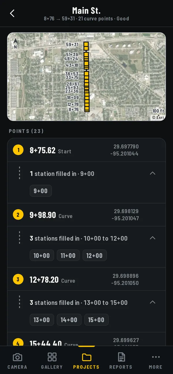
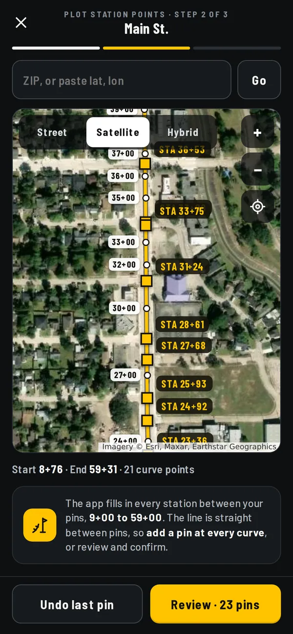
Drop pins on the map where your plan set shows stations: the start, the end, at least one in between and each curve. Station Cam fills in every 100 ft between them.
Shoot as usual
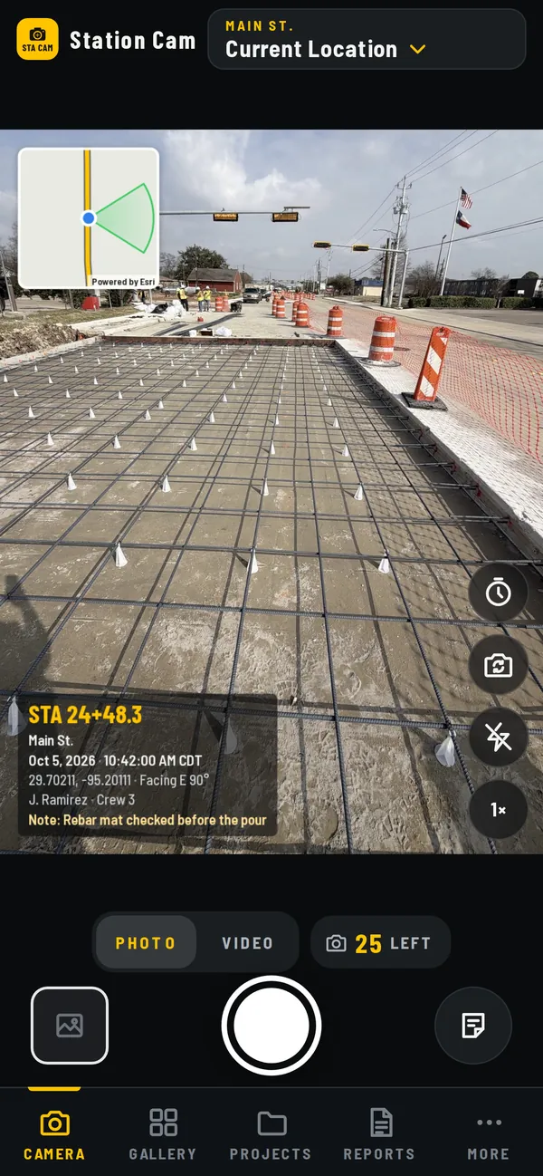
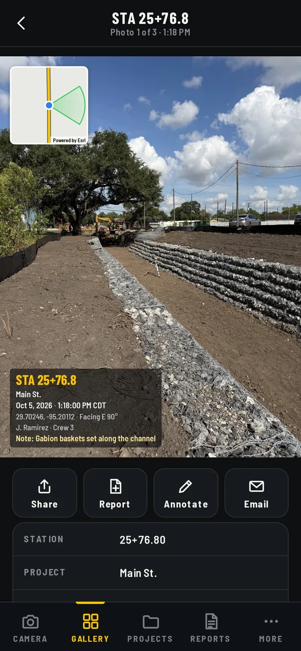
Every photo and video gets the station, date, time, GPS, heading and a small map, right on the image. No whiteboard in the shot.
Find it by station
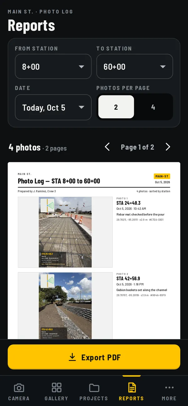
Photos sort along the road. Pick a station range and a day, and export a PDF photo log for the daily report.
Why Station Cam
Built for heavy civil and roadway work.
Most jobsite photo apps stamp the time and GPS. On a road job, the plans, the pay items and the inspector all go by station, so Station Cam puts the station on every photo, and you set the stations yourself.
- You set the stations. Open your plan set, drop a pin on the map at the start, the end, at least one point in between and every curve, and type each station. A short tour shows how the first time you open the app. No design files, no surveyor.
- Every station in between, filled in. Station Cam lays out the stations along the center line and stamps the right one on each photo, anywhere up to 200 ft either side of the road.
- Made for road crews. Highway, bridge, drainage and utility work: photo logs sorted by station, US or metric stationing, and it keeps working with no signal.
Phone GPS is usually good to 10 to 15 ft in the open: plenty to find and sort photos, not for laying out work.
What's in it
Built for stationing, not selfies.
-
The station on every photo
Stamped as you shoot, in US feet like
125+47.30or metric like3+824.417, with date, time and coordinates. An optional street address comes from your phone. -
A map on the photo
A small map window shows the road line, where you stood and which way the camera faced. Street, satellite or hybrid.
-
One project per road
Each project keeps its own code in the file names, like
US290_STA125+49, and the camera shows which one you're in. -
Photo logs by station
PDF logs sorted along the road, two or four photos a page, with your company logo on every page.
-
No signal, no problem
Stationing runs on the phone. Shoot in a cut, under a bridge or out past the last tower.
-
Your photos stay yours
Photos and projects stay on your phone and in your Photos app. No account, nothing uploaded unless you share it.
Pricing
Free to start. Pro when the crew needs more.
Free
$0
No account, no card.
- 5 photos a day
- More from short ads: 5 photos for the day's first, then 10 for each one after
- Every stamp, map, project and photo log
- Checks in with Station Cam every 3 days
Pro No ads
$12.99 a month
or $119.99 a year, about 3 months free
- 1,500 photos a month
- No ads, no check-ins
- Need more in a month? 500 photos for $4.99 that never expire
- Everything in Free
Prices in US dollars. Pro is bought in the app through the App Store or Google Play and renews until you cancel in your phone's settings. Crew plans with shared projects and cloud backup are on the way: tell us what your crew needs when you sign up.
Questions
What crews ask first.
How accurate is the station?
As accurate as the phone's GPS, which is usually within 10 to 15 ft in the open. That's plenty to find and sort photos by station. It isn't meant for laying out work.
Do I need design files or a surveyor?
No. You need the station numbers on your plan set and a map. Drop a pin at the start, the end, at least one point in between and each curve, and type the station from the plan sheet.
Does it work on curves?
Yes. Add a pin at each curve point. The more points you plot, the closer the stations follow the road.
Does it work with no signal?
Yes. Stations and stamps are worked out on the phone. On the Free plan, photos taken with no signal go on a tab you pay back with short ads once you're back online, and the phone checks in with Station Cam once every 3 days.
iPhone or Android?
Both. The apps are coming to the App Store and Google Play. Join the early-access list and we'll email you the day they're out; Android crews can test before launch.
Does it do metric stationing?
Yes. Pick US feet, like 125+47.30, or metric, like 3+824.417.
Where are my photos stored?
On your phone and in your Photos app. There's no account and nothing is uploaded. Share photos and PDF logs through your phone's share sheet.
What does it cost?
The Free plan gives 5 photos a day, plus more from short ads. Pro is $12.99 a month or $119.99 a year for 1,500 photos a month with no ads.
Early access
Be first on the job with it.
Leave your email and we'll tell you the day Station Cam lands in the App Store and Google Play.
- One email at launch, and only about Station Cam
- Android crews can test the app before anyone else
- Tell us what your crew needs next
You're on the list.
We'll email you the day Station Cam is in the stores.